Photo by Saul Greenberg
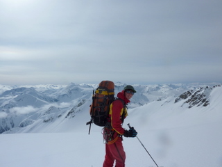
Spearhead Traverse: GPS and Maps (Near Whistler, BC)
Summary
- Ski Traverse appropriate for competent ski mountaineers
- ~41 kms total (according to my GPS), exiting via Singing Pass.
- 1 day (for speed skiers), 2 days (for fast tourers with a heavy pack), 3 days (in case of bad weather and for the odd ski ascent), 4 or more (to ski/climb all the peaks your heart may desire). I've been told its been done in 4 hours. Gasp.
- Elevation gain: See the profile included on the map. What makes this superb is that you gain a huge amount of elevation by taking lifts to the top of Blackcomb. While there is still lots of up and down (~2000m overall), most of the elevation gains are modest (i.e., a few hundred meters between cols and gaps)
- Trailhead: Blackcomb ski area, taking lifts to the top.
|
Spearhead Traverse Maps | |
|
Spearhead Traverse GPS Data (waypoints and track) |
Personal thoughts.
This route has been on my list for years. While its probably one of the most often done ski traverses in Canada, it is truly spectacular. What blew me away about it was how this route goes through big mountain country, yet it manages to thread its way through these spectacular peaks via relatively gentle glaciers in between a myriad of high cols. In late spring (when I did it) the glaciers were so well covered that crevasses on the route were almost invisible.
Numerous people do this in a single day, and this is very achievable by a fit and knowledgeable skier. But I must admit that I would only do that if the weather and snow looked perfect (or if I was very very familiar with the route). For example, we (my son Adam and I) started off on a great day, but by 2pm we couldn't see 10 feet in front of us. So we camped. Even if you have a GPS, you probably want to avoid travelling in a severe whiteout because there are a few cliffs, wind rolls, etc. But even more important, a major point of this trip is the spectacular views.
And what about the skiing? If you do the trip strictly as a tour without any ski ascents, you'll find the skiing somewhat ho-hum, as most of the time you are sidehilling up and down glaciers. There aren't really that many great descents. But (and this is a big but) if you have the time, you can do an incredible amount of skiing on the slopes that you pass by. You can also ascend myriads of peaks along the way - most are a short distance from your high points. So the amount of ski yeehaws depends on you. If you just want to get through the traverse, its a great tour. If you want to take the time and camp out several days, you can do tons of incredible skiing.
Details.
The maps above include a 1 page text description, and the GPS data includes waypoints and the route track. However, these should be considered a supplement to the commercial map titled 'Backcountry Whistler' (aka John Baldwin's map) which shows not only the primary route, but variations and ski ascents. Baldwin's book also has route description. But I was surprised how hard it was to find a detailed GPS route, which is why I include mine here. My maps are also very detailed, so you will also see small terrain features that are a bit harder to spot on Baldwin's map. Take both.
Cautionary notes.
- There are several small variations, where you can avoid some elevation loss by traversing steeper slopes. Take care on these. Some can be quite exposed, especially if the avalanche conditions are not great or the sun is shining. If lighting is bad and you are following other people's tracks, you may get sucked onto a variation without realizing it. I think that the 1-day skiers mostly take these, because they are not burdened by heavy packs. But having said that, we did them all but one: we turned back from under Mt. Fitsimmons because we didn't like the snow conditions on it.
- Even though much of the route travels on low-angle glaciers, it sometimes traverses under steep slopes above. Again, watch for avalanche conditions.
- Glaciers on this trip are pretty awesome. But there are big holes under all that snow. Ropes, harnesses, etc are a good idea, but its up to you.